Land use change in Ambikapuram Valley, Coonoor
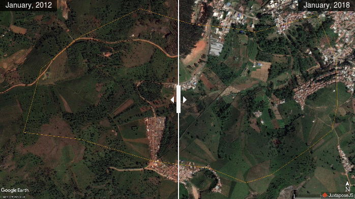
Ambikapuram valley is an area of over 200 acres in Hubbathalai Panchayat, Coonoor Taluk in the Nilgiris district of Tamil Nadu. This valley is a typical example of many such across the district. There are springs in the upper reaches, streams and wetlands in the valley that are major sources of water supply. Changes in […]
[Help] Using Google My Maps
The spring atlas has been created using Google My Maps. You don’t need a Google account in order to browse the map or to download the data. In order to make browing easier, click on the icon on the top right hand corner to open a new browser window with the map (See image below). […]
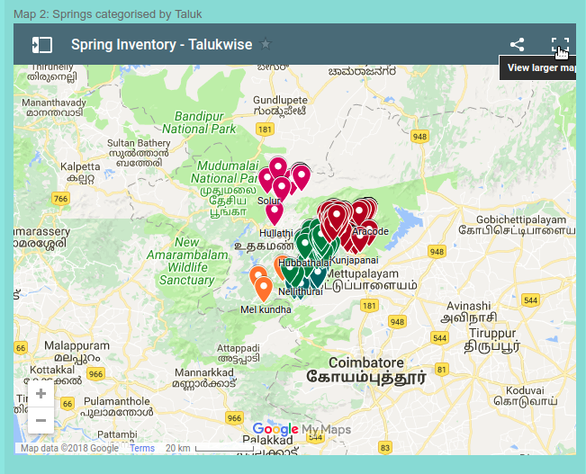
A Spring Atlas of the Nilgiri Biosphere Reserve (Beta version)
Introduction There is a lack of data on the number and locations of springs in the country as a whole. The Nilgiris is no exception to this. While local inhabitants can possibly reel off names of springs close to them, no one person/institution has data on the locations of all the springs in the region. […]
Springs in Kotagiri town
We are currently undertaking a survey of all water sources in Kotagiri town with a view to identifying conservation issues and providing management plans to the Town Panchayat. We have already collaborated with the Town Panchayat to conserve the springshed in Happy Valley since 2006. We have now embarked on identifying other such places in […]
Land cover change in the catchment of Thalaikundah (2006 – 2016)
The Thalaikundah wetland is located next to a National Highway (Ooty-Mysore) and is subject to pressure from locals and tourists. The time slider lets us explore any changes in land cover in the last ten years.
Land cover change around Yedappalli wetland (2012-2016)
The wetland above Yedappalli village in Coonoor taluk is an important source of water. The water flows from here are tapped downstream by the Municipality to supply water to the town. Locally there are two temples near the wetland that are using the water directly from the wetland. By comparing the images from 2012 and […]
Land cover change in Elada Dam catchment (2008-2015)
The Elada dam is an important water source for Kotagiri town in the Nilgiris. It has become dry a couple of months back and this prompted us to revisit it and see what has changed, apart from the poor rainfall this year. One easy way to look at changes over time is to use historical […]
Map of springs inventory in the Coonoor region, The Nilgiris
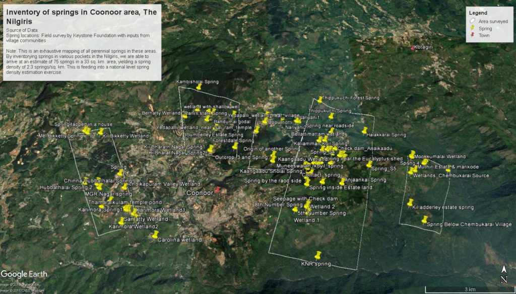
Over the last two years, Keystone has been mapping locations of perennial springs along with some baseline data. This is a first attempt of its kind in the Nilgiris as far as we know. Certainly no map or list of springs in this landscape is readily available to the public. Here’s a map of the […]
Shapefiles for Coonoor landuse layer
The Landuse of Coonoor region was derived from visual interpretation of Google Earth imagery and ground truthing. The imagery in Google Earth is from January 2012. We are not claiming accuracy of these layers as we are not experienced at remote sensing analysis. We have attempted this to get a general picture of the land use of the […]
