Aracode
Aracode region is the Eastern most part of the Nilgiris which falls under the Kotagiri Taluk. There are Kurumba and Irula settlements in the dense forests where we carry out inventory and monitoring of wells with the help of community volunteers. Along with the quantity of water available in different seasons the quality of water also varies. The water quality can have health implications for people and wildlife.
The data is being collected using Open Data Kit (ODK) forms on Android tablets. As soon as the data is submitted the charts below will get updated automatically. We hope that sharing this data in the public domain will contribute to better understanding and management of our groundwater resources. The charts have been made using Tableau Public software. For the best viewing experience kindly open the charts in a separate window by clicking on the bottom right corner of each chart. Please leave your comments and suggestions in the comment section.
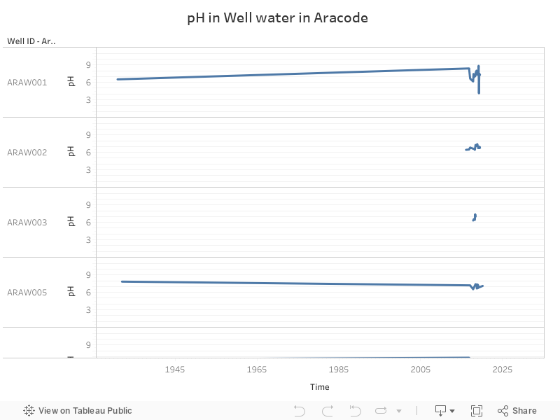
pH
pH is the measure of acidity or alkalinity of water. If the water is acidic then it has a pH in the range of 0 to 6.9. If a solution is alkaline then it has a pH in the range of 7.1 to 14. Pure water or deionized water is neutral at pH 7.0.
Bureau of Indian Standards – Desirable – 7, Permissible Limit- 6.5-8.5
Risks or effects – Low pH – corrosion, metallic taste
High pH – bitter/soda taste, deposits
Sources – Natural
Treatment – Increase pH by soda ash
Decrease – pH with white vinegar / citric acid
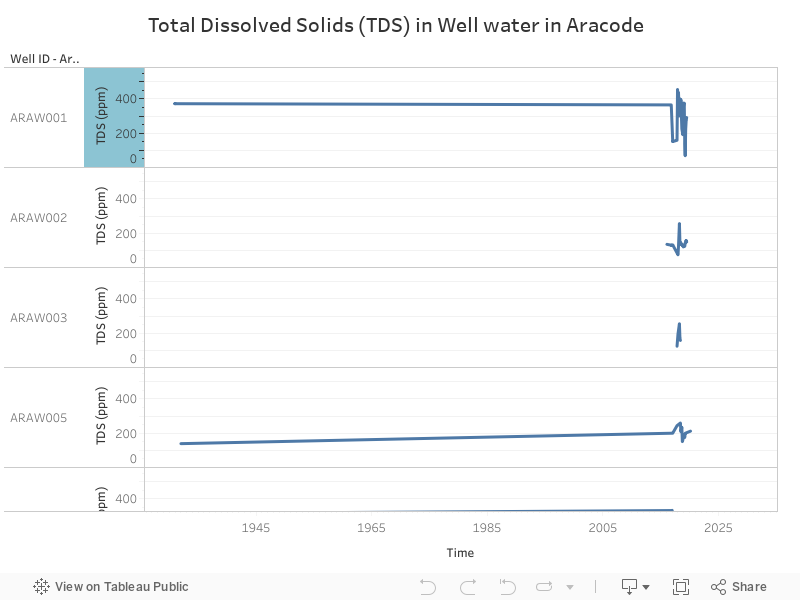
TDS
Total dissolved solids (TDS) is a measure of the dissolved combined content of all inorganic and organic substances in a liquid in a molecular, ionized or micro-granular (colloidal soil) suspended form.
Bureau of Indian Standards – Desirable – 500 mg/l, Permissible Limit – 2000 mg/l
Risks or effects – Hardness, scaly deposits, sediment, cloudy colored water, staining, salty or bitter taste, corrosion of pipes and fittings
Sources – Livestock waste, septic system, Landfills, nature of the soil, Hazardous waste landfills, Dissolved minerals, iron and manganese
Treatment – Reverse Osmosis, Distillation, deionization by ion exchange
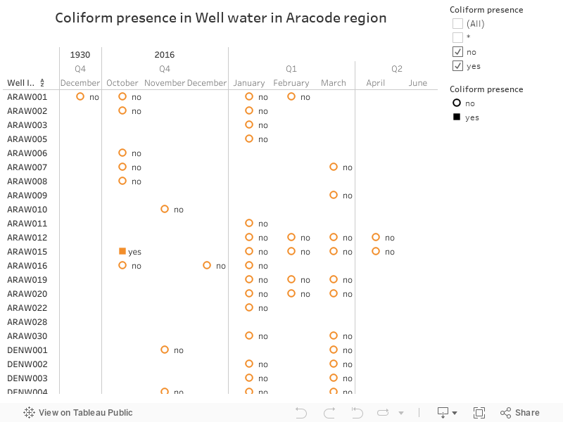
Coliform presence
Coliforms are a broad class of bacteria found in our environment, including the feces of man and other warm-blooded animals. The presence of coliform bacteria in drinking water may indicate a possible presence of harmful, disease-causing organisms.
Bureau of Indian Standards – Coliform in Water must be zero or absent.
Risks or effects – Gastrointestinal illness
Sources – Livestock facilities, septic systems, Manure lagoons, Household wastewater, Naturally occurring
Treatment – Chlorination, Ultraviolet, Distillation, Iodination
Depth to water level of wells in Aracode
Depth to water level is measured from the top of the well to the water surface at different points in time and season during the year. The Water levels in your wells change from season to season and this can be monitored using a simple measuring tape. This measure is useful in tracking seasonal changes in water level in a well.

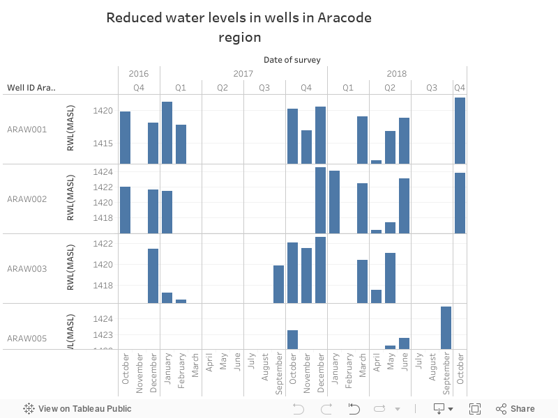
Reduced water levels of wells in Aracode
The Reduced water level is the water available at each well with regards to the mean sea level. In a hilly terrain, different wells may be located at different elevations. In order to compare water levels across different wells, the water level is converted to the height above mean sea level.
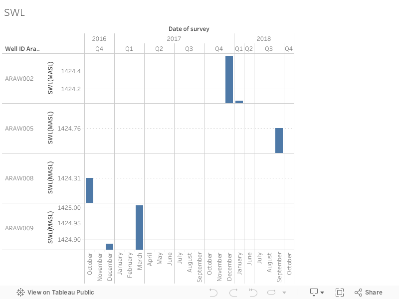
Standing water levels of wells in Aracode
The Standing water level is the height of the water column in the well. This indicates the amount of water available for consumption for human beings and/or wildlife.
Excellent blog you have got here.. It’s difficult to find excellent writing like yours these days.
I honestly appreciate individuals like you! Take
care!!