Rainfall across the Nilgiri Biosphere Reserve
Rainfall Data from automated and manual rain gauges collected by Keystone Foundation with help of community volunteers.The rain gauge IDs used in the visualization below correspond to the following locations. RG001 -Kotagiri RG002 -Coonoor RG003 -Aracode RG004 -Sigur RG008 -Konvakarai RG009 -Pillur To download the raw data used in the above visualizations, check out this […]
Land use change in Ambikapuram Valley, Coonoor
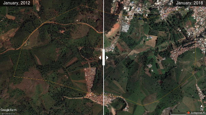
Ambikapuram valley is an area of over 200 acres in Hubbathalai Panchayat, Coonoor Taluk in the Nilgiris district of Tamil Nadu. This valley is a typical example of many such across the district. There are springs in the upper reaches, streams and wetlands in the valley that are major sources of water supply. Changes in […]
Map of springs inventory in the Coonoor region, The Nilgiris
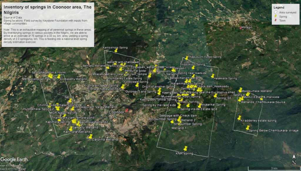
Over the last two years, Keystone has been mapping locations of perennial springs along with some baseline data. This is a first attempt of its kind in the Nilgiris as far as we know. Certainly no map or list of springs in this landscape is readily available to the public. Here’s a map of the […]
PES project Reports for Coonoor
We have been looking at the Payment for Ecosystem Services approach as a potential way to address the water crisis in Coonoor. The final reports of this effort are shared here. Hydrogeological assessment of the catchments of three water sources of Coonoor Recommendations for Development of a PES Project in Coonoor Note on a PES […]
Presentation from the CEPF Evaluation Meeting on 4th July 2013
The work done on the Mainstreaming… project was presented to CEPF partners ‘ group at Kotagiri on 4th July 2013. The presentation file can be accessed from here. We received valuable feedback including a suggestion to look at conversion of landuse to grasslands category as it would have greater impact on hydrological flows. We intend […]
Poster on the Simulation Model and Inferences
We have published a poster that summarises the details of the simulation model developed as part of the ‘Mainstreaming conservation in district public policy’ project. This poster can be used by anyone interested in advocating a change in the way water resource use and management is being approached at policy and implementation levels. As with […]
Shapefiles for Coonoor landuse layer
The Landuse of Coonoor region was derived from visual interpretation of Google Earth imagery and ground truthing. The imagery in Google Earth is from January 2012. We are not claiming accuracy of these layers as we are not experienced at remote sensing analysis. We have attempted this to get a general picture of the land use of the […]
Model files and presentation at UPASI, Coonoor on 11th June 2013
At 11 AM on 11th June, at UPASI in Coonoor a meeting is being held in which representatives from District Administration and various departments, prominent academic and research institutions etc. are expected to participate. The District Collector, The Nilgiris District would be the chief guest. The presentation to be made at the meeting is available […]
Mainstreaming Conservation in District Public Policy
The project proposes to influence existing policies pertaining to, – Use of pesticides – Municipal sewage and waste disposal – Land use change, including planting of exotic species Downstream impacts on livelihoods and ecology: The Coonoor river will be taken up a case study. This will measure and prove need for conservation action and protection […]
The Context
The Nilgiris have seen a drastic change in land use pattern over the last century or so with shola forests and grasslands being replaced by monoculture plantations, habitations, farmlands etc. There is also an ever increasing population settled locally as well as a significant floating population that visits the Nilgiris for tourism. The pressure of […]