Rainfall across the Nilgiri Biosphere Reserve
Rainfall Data from automated and manual rain gauges collected by Keystone Foundation with help of community volunteers.The rain gauge IDs used in the visualization below correspond to the following locations. RG001 -Kotagiri RG002 -Coonoor RG003 -Aracode RG004 -Sigur RG008 -Konvakarai RG009 -Pillur To download the raw data used in the above visualizations, check out this […]
About Streams
The Nilgiris district can be divided into four basins. Moyar Basin and its 24 rivers – draining mainly into the Bhavani reservoir as water supply for irrigation and drinking water in Tamil Nadu. Bhavani Basin and its 26 rivers – draining again to the Bhavani reservoir along the district boundary and onwards again into the […]
A Spring Atlas of the Nilgiri Biosphere Reserve (Beta version)
Introduction There is a lack of data on the number and locations of springs in the country as a whole. The Nilgiris is no exception to this. While local inhabitants can possibly reel off names of springs close to them, no one person/institution has data on the locations of all the springs in the region. […]
Spring Hydrograph of Happy Valley, Kotagiri
Keystone has been monitoring the spring discharge and water quality in Happy Valley with a view to build a long term dataset that would help in managing the water resources. The data and a spring hydrograph are shared below. The report uses the free Google Data Studio app.
Springs as water sources in the Nilgiris: An economics perspective
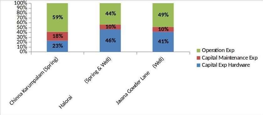
Have we ever wondered how much it costs to tap water from natural sources like springs and wells? Well, if you say that the water we receive at our houses is for free of cost, then you may need to read further to know the number of works that take place at different levels of […]
Wetland Management Plans
Management Plan The first stage of the project was concerned with collection of data on wetlands from prominent wetlands of the Nilgiris. An attempt was made to cover as many wetlands as possible and from as many representative areas in the Nilgiris. However, the more we studied about wetlands; we realized that we have barely […]
First Survey of Wetlands in the Nilgiris (2006)
Keystone conducted a baseline survey of 38 hill wetlands. We have mapped, inventorised flora, fauna and people dependence on wetlands. Wetlands have been classified in different categories as common property resources – in rural and urban areas and in private and protected areas. In each of these categories a threat assessment has been made and […]
About Wetlands
Wetlands of the Nilgiri region are unique, unlike wetlands in general – these are small sized hill wetlands, life giving in nature…habitat for a variety of wildlife, flora and meet the needs of the people. These wetlands are fragmented in small random patches – with underground connectivity of water channels. There are no dramatic landscapes […]